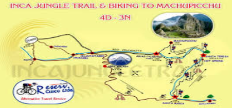
The Inca Jungle Trek stands out as one of Peru’s most exhilarating alternatives to the classic Inca Trail, blending high-altitude thrills with lush rainforest immersion on a journey that culminates at the iconic Machu Picchu. If you’re plotting your path through Peru’s diverse landscapes, the Inca Jungle Trek map becomes your essential compass—detailing a route that descends from Andean peaks to verdant lowlands, incorporating mountain biking, hiking, zip-lining, and optional rafting. This 4-day adventure covers approximately 70-80 kilometers, offering a dynamic alternative for those seeking variety beyond stone-paved ruins. In this guide, we’ll dissect the Inca Jungle Trek map, explore its itinerary, and equip you with professional insights to ensure a seamless expedition.
Whether you’re an avid adventurer or a cultural explorer, understanding the Inca Jungle Trek map reveals not just distances and elevations but the heartbeat of Peru’s natural and historical tapestry. Let’s navigate this route step by step.
What is the Inca Jungle Trek?
The Inca Jungle Trek is a multi-activity odyssey designed for those craving adrenaline alongside Andean heritage. Originating as a modern counterpoint to the permit-restricted Classic Inca Trail, it weaves through the transition zone between the high Andes and the Amazon basin, showcasing biodiversity from snow-capped passes to tropical canopies. Unlike the archaeological focus of the traditional path, this trek emphasizes physical challenges and eco-adventures, making it accessible yet invigorating for travelers with moderate fitness levels.
Historically, the route echoes ancient Inca trade paths that linked highland societies with lowland resources, though today’s version amps up the excitement with contemporary elements like downhill biking from elevations over 4,300 meters. Spanning four days and three nights, it starts in Cusco and ends in the shadow of Machu Picchu, with no mandatory permits required—ideal for spontaneous planners. The Inca Jungle Trek map visually captures this descent: a serpentine line dropping from the Abra Málaga pass (4,350 meters) to the Urubamba River valley (around 1,400 meters), punctuated by key waypoints like Santa María and Santa Teresa.
Why Choose the Inca Jungle Trek Over the Classic Inca Trail?
For many, the Inca Jungle Trek map appeals due to its flexibility and thrill factor. The Classic Inca Trail, while steeped in history with sites like Wiñay Wayna, demands advance permits (capped at 500 daily) and follows a more uniform hiking rhythm over 42 kilometers. In contrast, the Jungle Trek skips the crowds, offering uncapped access and a mosaic of activities that keep energy high.
Opt for this route if you thrive on variety: imagine pedaling through cloud forests one moment and soaring via zip-line the next. It’s less physically grueling in terms of sustained ascents but introduces water-based and aerial elements, perfect for families (minimum age 12) or groups seeking cultural dips into Quechua communities. Environmentally, it promotes sustainability by traversing less-trafficked paths, reducing erosion on overused trails. Plus, the Inca Jungle Trek map highlights immersive stops, like thermal springs and coffee plantations, fostering a deeper connection to Peru’s living landscapes.
Detailed Inca Jungle Trek Map and Route Overview
At its core, the Inca Jungle Trek map illustrates a dramatic altitudinal plunge: from Cusco’s 3,400-meter perch to the humid embrace of the Amazon fringe, with Machu Picchu crowning the finale at 2,430 meters. The overall path spans 70-80 kilometers, blending vehicular transport, biking (45 kilometers downhill), hiking (about 30 kilometers), and adventure segments.
Key cartographic features include:
- Starting Elevation Gradient: A steep drop from Abra Málaga (4,350 meters) signals the shift from páramo grasslands to subtropical zones.
- Riverine Corridors: The Urubamba River snakes through the map, guiding Days 2 and 3 with rafting opportunities and lush riparian trails.
- Adventure Nodes: Marked zip-line courses near Santa Teresa (1,800 meters) and the Hydroelectric Dam (1,900 meters) add vertical drama.
- Endpoint Convergence: Tracks converge at Aguas Calientes (2,040 meters), a mere 6-kilometer hike from Machu Picchu’s gates.
Visually, most Inca Jungle Trek maps employ color-coded lines—blues for rivers, greens for jungle hikes, and reds for high passes—to denote terrain changes. Distances are segmented daily, with total descent exceeding 2,900 meters, emphasizing acclimatization to prevent altitude woes. This layout not only aids navigation but underscores the trek’s biodiversity: expect orchids, toucans, and spectacled bears amid mahogany groves.
Day-by-Day Itinerary: Following the Inca Jungle Trek Map
Day 1: Cusco to Santa María – The Adrenaline Descent
Dawn in Cusco (3,400 meters) launches with a 3-hour drive to Abra Málaga (4,350 meters). Here, the Inca Jungle Trek map unfurls its first thrill: a 45-kilometer downhill bike ride through Andean cloud forests, veering to the Inca ruins of Huamanmarca. Elevation plummets to Santa María (1,430 meters), where optional 5-kilometer rafting on the Urubamba River caps the day. Total: 6 hours active, overnight in basic lodges.
Day 2: Santa María to Santa Teresa – Jungle Immersion
Uphill undulations (16 kilometers) trace the map’s verdant veins, crossing suspension bridges and coffee fincas en route to Quellomayo for lunch. The path hugs the Urubamba, ascending gently to Santa Teresa (1,550 meters). Relax in natural hot springs, a restorative nod to weary muscles. This segment, 6 hours of moderate hiking, reveals the trek’s ecological richness.
Day 3: Santa Teresa to Aguas Calientes – Aerial and Aquatic Peaks
The Inca Jungle Trek map elevates excitement with a 2,500-meter zip-line circuit (six lines, longest 1,000 meters at 70 km/h) over the Amazon canopy. Follow with a short hike to the Hydroelectric Dam, then 10 kilometers along railway tracks to Aguas Calientes (2,040 meters). Optional waterfall climbs add spice. 5-7 hours total, blending height and horizon.
Day 4: Aguas Calientes to Machu Picchu – The Grand Reveal
Bus or foot ascent (390 meters) to Machu Picchu (2,430 meters) allows 4-6 hours of exploration: Temple of the Sun, Intihuatana stone, and panoramic vistas. Descend via the same path, train back to Cusco. The map’s finale loops this sacred circuit, a 969-meter round-trip hike option for the ambitious.
Highlights and What to Expect on the Inca Jungle Trek
Expect a sensory feast: mist-shrouded bikes, river splashes, and zip-line whooshes amid Peru’s endemic flora (bromeliads, cedars) and fauna (monkeys, otters). Cultural vignettes—Quechua weavings, coca leaf rituals—pepper the route, while lodgings evolve from rustic to riverside comfort. Challenges include variable weather (pack layers) and moderate exertion, but guides ensure safety with gear and briefings.
Preparation and Packing Tips for Your Inca Jungle Trek
Acclimatize in Cusco 2-3 days pre-trek; cardio train for endurance. Essential packing: waterproof jacket, hiking boots, insect repellent, sunscreen, water bottle, snacks, passport, and cash (soles). Travel insurance covering adventure sports is non-negotiable. Book with reputable operators for porters and meals (vegetarian options available).
Best Time to Trek and Difficulty Level
Dry season (May-October) shines for clear skies and dry trails; June-August peaks with crowds. Rated moderate, it’s suitable for fit beginners—no prior skills needed, but altitude (max 4,350 meters) demands respect. Women and solo travelers report high safety with group dynamics.
Conclusion: Embark on the Inca Jungle Trek Today
The Inca Jungle Trek map isn’t merely a guide—it’s an invitation to Peru’s wild heart, fusing adventure, culture, and wonder en route to Machu Picchu. This route’s blend of descent, diversity, and discovery makes it a standout for 2025 explorers. Whether zip-lining over jungles or hiking ancient echoes, you’ll emerge transformed. Secure your spot early, lace up, and let the map lead you to indelible memories.

